- Aasiya Niaz
- 25 Minutes ago
Chinese commercial satellites track USS Gerald R. Ford in red sea
-

- Web Desk
- 11 Minutes ago
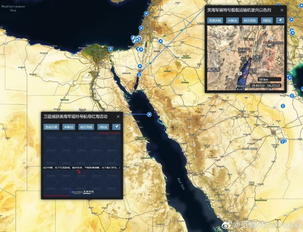
WEB DESK: In a striking demonstration of the expanding capabilities of commercial satellite intelligence, Shanghai-based geospatial firm MizarVision has released imagery purportedly showing the United States Navy’s flagship supercarrier, USS Gerald R. Ford, manoeuvring in the northern reaches of the Red Sea, off the Saudi coastline near Al-Jawfah.
According to the Maritime Executive, the high-resolution photographs began circulating over the weekend across defence monitoring accounts and social media platforms. They appeared only days after the carrier completed its southbound passage through the Suez Canal on 5 March. Official US Navy imagery confirmed the transit, with the vessel escorted by the guided-missile destroyer USS Bainbridge (DDG-96) as it entered the Red Sea en route to the operational theatre overseen by United States Central Command.
Carrier presence near regional flashpoints
According to the imagery attributed to MizarVision, the immense silhouette of the Ford-class carrier displacing more than 100,000 tonnes and capable of embarking over 75 aircraft appears positioned roughly 100 kilometres off the Saudi coastline. Several analysts who reviewed the images indicated that the annotated coordinates place the vessel within proximity of multiple regional flashpoints.
The deployment forms part of a broader American naval reinforcement amid rising tensions across the Middle East, particularly following the launch of Operation Epic Fury and the subsequent escalation involving Iran. With the arrival of the Ford strike group, Washington is now believed to maintain a two-carrier presence in the region, a posture intended to reassure allies while signalling deterrence against further escalation.
Growing reach of commercial satellite intelligence
What has drawn particular attention within defence circles, however, is the provenance of the imagery. MizarVision, a relatively young yet increasingly visible Chinese geospatial intelligence company, has in recent weeks published a series of detailed observations of American military activity across the region. These have ranged from aircraft deployments at Prince Sultan Air Base to carrier movements through strategic maritime chokepoints.
Analysts note that the open dissemination of precise positional data on US naval assets underscores the growing transparency brought about by commercial satellite constellations. The trend also highlights the expanding role of private firms particularly those originating in China in providing near-real-time geospatial intelligence accessible to the public.
The company has not specified whether the imagery derives solely from its own satellites or incorporates data from partner constellations, though previous releases during the current crisis have prompted speculation that multiple sources may be integrated.
Neither the United States Department of Defense nor the US Navy has issued an immediate response to the images. Officials have consistently confirmed the carrier’s presence in support of ongoing operations while declining to disclose precise locations for operational security reasons.
As the Red Sea continues to serve as a crucial artery for global commerce despite persistent threats from Houthi militants and wider regional instability the reported presence of the USS Gerald R. Ford near Saudi waters offers a stark reminder of the delicate balance of power in one of the world’s most strategically sensitive maritime corridors.
You May Also Like