- Web Desk
- Yesterday
Southern Punjab faces worst of floods, breach planned near Multan
-

- Web Desk
- Sep 09, 2025
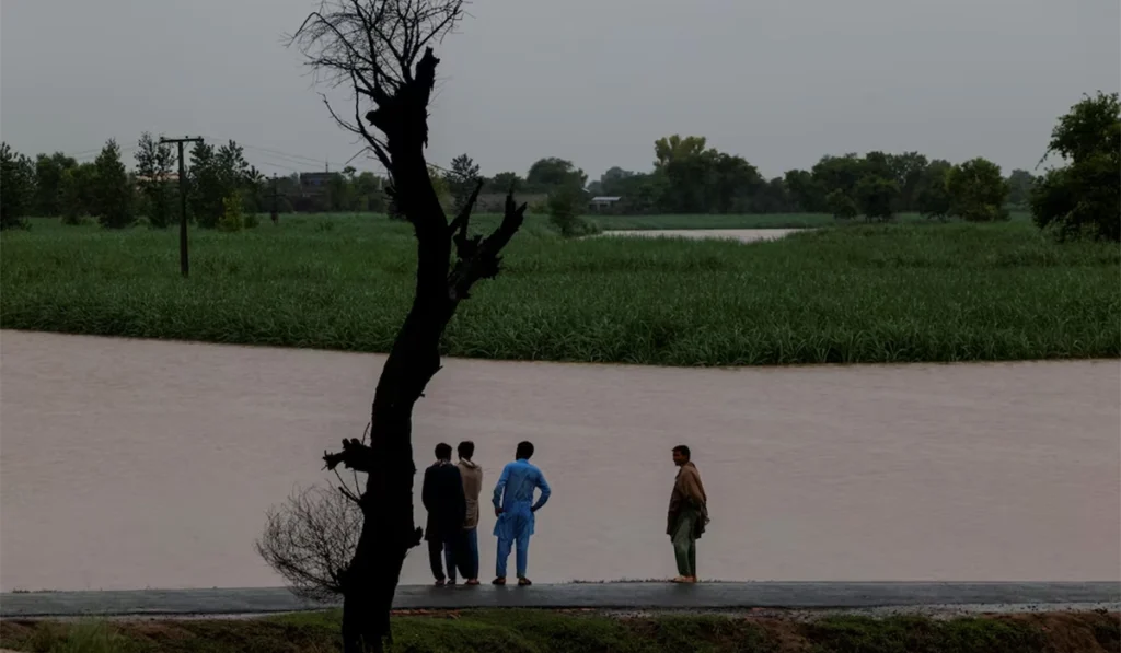
ISLAMABAD: Situation remained critical in Multan, Jalalpur Pirwala and surrounding areas sandwiched between Chenab and Sutlej on Monday with a dangerous waterflow at Panjnad as authorities continued evacuating citizens amid the threats of floodwaters breaching dykes around the city.
And late on Monday night, authorities warned that they could breach the Sher Shah Bund — a protective levee near Multan city — any time amid alarming rise in water level.
The dyke is named after the town itself — Sher Shah. It is in the southwest of Multan city at a distance of around 18 kilometres.
In this connection, the officials had started making announcements, asking the locals to leave their homes and shift to safer locations.
Earlier, Provincial Disaster Management Authority (PDMA) DG Irfan Ali Kathia had warned at a press conference that Multan (city and surrounding areas) would be at high risk during the next 48 hours.
Among the possible measures to protect Multan, he said, there was an option to breach the protective levee at Sher Shah Bridge near the city, but any decision would be taken on the basis of latest data and recommendations of technical experts.
Kathia said the authorities took timely decisions on planned breaches to protect the people in urban centres after proper technical input, as he cited the examples of blown up dykes at Mai Safooran Dam near Sidhnai Headworks and Rivaz Bridge in Jhang among others.
The death toll in Punjab floods had reached 61, he said, adding that the record-shattering floods affected 26 districts.
JALALPUR PIRWALA
Earlier on Sunday, the government had directed the people to leave the Jalalpur Pirwala city and had started a rescue operation to transport them to safety.
Read more: Evacuation orders for Jalalpur Pirwala amid Chenab, Sutlej threat
Chief Minister Maryam Nawaz himself monitored the process late into the night while the National Disaster Management Authority (NDMA) DG reached the area to supervise the government response.
Floodwaters from Chenab and Sutlej have already submerged dozens of villages and settlements in Jalalpur Pirwala tehsil.
SUTLEJ
And in Kasur, the Sutlej River was in exceptionally high flood with a discharge of 319,295 as the persistent flooding had started to weaken the protective levees including the one at Talwar Post.
The situation is a result of Sutlej witnessing high to exceptionally high flood at Ganda Singh Wala since August 20, with a peak of 385,569 cusecs on August 29.
INTENSE RAINS
Meanwhile, the strong monsoon weather system was producing intense rains in southern, central and northeastern Punjab — a region already devastated by record-breaking floods and coping with the rising waters of Chenab and Sutlej.
In this connection, the PDMA chief said Multan and Faisalabad had received excessive rain on Monday, which would make the rescue efforts even more difficult.
Satellite images taken at 6:20pm showed dark clouds covering an area from Kasur and Lahore in the south to Narowal and Sialkot in the north, producing moderate to heavy rains.
At Pani Wala Talab, one of the locations in Lahore, the amount of rain recorded was 112mm.
Moreover, the upper parts of Punjab barring the region northwest of the Jhelum River were also under cloud cover.
Earlier in the day, the southern and central Punjab witnessed heavy rain that multiplied the miseries of flood-hit people in rural areas while generating urban flooding-like situation in cities and towns.
Meanwhile, heavy rain was also lashing Multan and surrounding areas as well as Dera Ghazi Khan and Koh-e-Sulaiman.
A vast region from Chiniot and Jhang to Multan is currently submerged and more areas are on the verge of being inundated as gushing waters swept away levees.
The same weather system was also generating downpours in Sindh which is set to start facing the floods in the coming days.
Upper, eastern and lower Sindh have received heavy rain and thunderstorm with gutsy winds not only Monday but also Sunday.
SOUTHERN HALF
In its evening daily report, the Met Office on Monday said a deep depression lied over southeast Sindh, and likely to move west-northwestwards during next 24 to 36 hours.
“Due to this weather system strong monsoon currents are likely to penetrate in southern half of the country. A shallow westerly wave is also effecting upper and central parts of the country”, it added.
INDUS WATERS TREATY
Meanwhile, the persistent alarming flood level at Ganda Singh Wala is a result of India releasing water from its reservoirs built on the two eastern rivers — Sutlej and Beas — without following the protocols set in the Indus Waters Treaty.
India had suspended the Indus Waters Treaty soon after the Pahalgam attack and isn’t sharing any information through Indus Water Commission, formally named as Permanent Indus Commission.
However, New Delhi has been forwarding information through diplomatic channels during the current floods, but the absence of complete data means Pakistan cannot take necessary actions on timely basis.
Read more: India shared flood warning through diplomatic channels, not IWT: FO
THE STATE OF RIVERS
The latest Flood Forecasting Division (FFD) data at 3pm on Monday showed that Sutlej was in exceptionally high flood — 319,295 cusecs — at Ganda Singh Wala.
It means Sulemanki and Islam in its downstream were also in high flood — 137,521 cusecs and 120,598 cusecs respectively. And the exceptionally high flood at Ganda Singh Wala with more waterflow from India expected means there is no relief in sight for the people living in the downstream areas.
Alarmingly, the waterflow at Ganda Singh Wala was rising with the reading at 9pm jumping to 327,030 cusecs.
On the other hand, water was rising at Sidhnai with the flow in Ravi recorded at 135,757 cusecs, representing exceptionally high flood which was ultimately feeding Chenab.
However, waterflow was decreasing at Balloki — 125,995 cusecs — and Shahdara — 67,980 cusecs.
But most worrying spot right now apart from Ganda Singh Wala was Panjnad with a very high flood of 524,762 cusecs at 3pm.
However, the flow was down to 480,961 cusecs by 9pm.
At Trimmu in the north, the river discharge was 531,993 cusecs, which remained steady at the same level.
It means flood threat would remain very high downstream of Trimmu as well as in and around Panjnad where the flow was bound to increase because of being the confluence of Chenab and Sutlej.
That’s why the waterflow at Guddu in Sindh had reached 411,161 cusecs by 4pm and was rising. It had reached 425,763 cusecs at 9pm.
You May Also Like